
Cherry Hinton, in Cambridge, has 4 sites of geological interest
Two of the four sites, East Pit and Giant’s Grave, are Local Geological Sites (LGS) and one, West Pit (part of the Cherry Hinton Pit SSSI with East Pit), is a candidate LGS. The fourth, Lime Kiln Close, is of interest for its remains of old kilns. All four sites are linked geologically and are located in the same area, adjacent to each other (or separated by just a road).
East Pit LGS
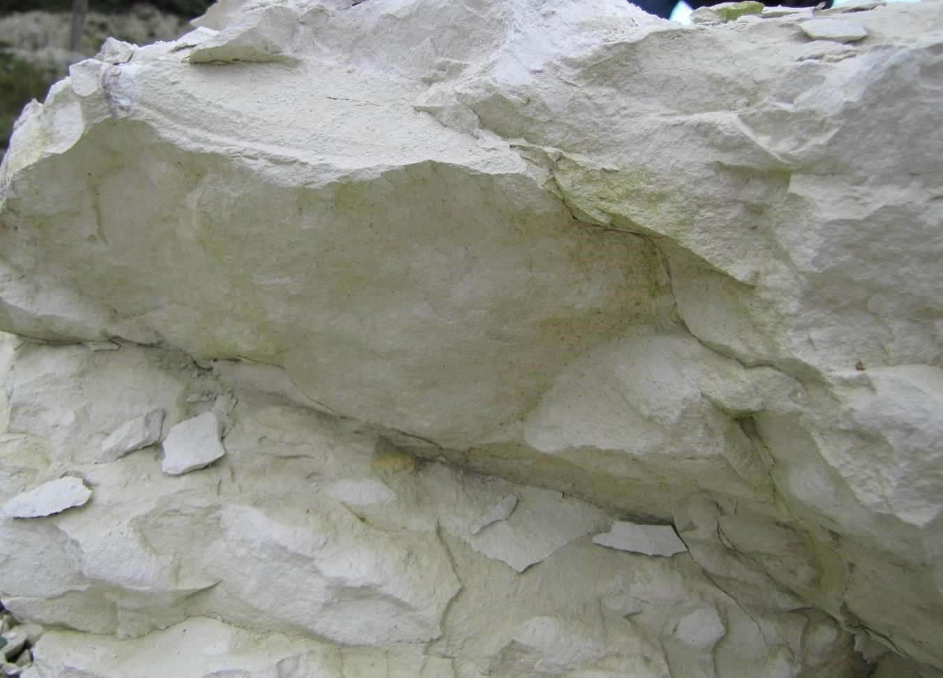
Local Geological Sites (LGS) are recognised for their local geological diversity and earth heritage value. East Pit was designated an LGS in February 2016. It is the largest of the three chalk quarries at Cherry Hinton (the others being West Pit and Lime Kiln Close, both adjacent to East Pit). It was worked up until the early 1980s and, along with the other two quarries, once provided hard chalk (clunch) for construction of local buildings, including some of the Cambridge University colleges, and lime for cement. There are few other places in the county where such extensive and accessible views of a sedimentary rock sequence are possible. The chalk deposits at the site represent a variety of depositional environments and a number of different rock units (the average rate of deposition has been calculated at 1cm in 1000 years). This is the only site in the county where there is a clear exposure of the Plenus Marls, allowing views of the strata both above this deposit (the Holywell Nodular Chalk Formation) and below (the Zig Zag Chalk Formation). The Plenus Marls and the overlying Melbourn Rock are at the base of the White Chalk and are traceable across much of the English Chalk.
The site provides an excellent view of the Cretaceous Chalk that underlies much of south-east England, reaching the surface in characteristic landscape features such as the North and South Downs, the Chilterns, the Lincolnshire and Yorkshire Wolds ad, locally, the escarpment running from Royston to Cambridge. The site is located on the edge of the Gog Magog Hills to the south-east of Cambridge, a major geomorphological feature of the county that has played a significant role in cultural, as well, as geological history.
History and use
Prehistoric human occupation at the site has been discovered and an Iron Age fort was discovered here in the late 19th century. From the late 19th century onwards, there have been a number of excavations at the site which have unearthed human remains dating from the Iron Age. An archaeological excavation, carried out in 2009, revealed the details of the Early Iron Age hill-fort surrounded by a ditch. Many fragments of Early Iron Age, Late Iron Age and Romano-British pottery were found along with the bones of cattle, horse, pig and sheep. The archaeological site is known as ‘The War Ditches’ and is one of four, strategically located, Iron Age forts in the area, one of the others being Wandlebury Ring. The archaeological evidence indicates that the hill-fort was destroyed with significant loss of life before being abandoned in 380 BC. The site was later used as a farmstead.
The site was a working quarry until the early 1980s. It was a major source of lime for mortar and quicklime for agriculture over many years. It also provided local building stone known as ‘clunch’ obtained from harder bands within the chalk, such as the Melbourn Rock. As a relatively soft stone, clunch weathers easily and is, therefore, more useful for inside use. It carves easily and is sometimes painted for decoration. Clunch obtained from the site was used from the 13th to the 15th centuries as a building material.
The Cherry Hinton Chalk Pits are referred to in several records of local buildings, such as Cambridge colleges, including that of King’s College which acquired a clunch pit at Cherry Hinton (likely to be East Pit) prior to 1452, and the material from it was probably used for building the earlier parts of its chapel. The great gateway at Trinity College and parts of Peterhouse in the late 15th century, and the chapel at Corpus Christi College in the 16th century were also built from ‘Hinton stone’. As a major industrial site within the suburbs of Cambridge, the pit and its ‘workings’ have been featured in several publications, some including photographs and drawings. Employment in quarrying at the site may have started as early as Roman times and has played a significant role in the history of Cherry Hinton and the surrounding area. Chalk and lime were transported a short distance to the Coldham’s Lane area where cement works operated from c.1895 to c.1956, forming another local industry in addition to the quarrying. The lives of the quarry workers through the centuries is of interest and, more recently, the use of the pit by the Home Guard in the 1940’s, as a site to practice scaling cliffs. The story of fossil collecting at the site, including the discovery of the large ammonite, is also of interest.
Fossils
Chalk is mainly composed of very large numbers of minute fossils (nanofossils), the skeletons of single-celled algae (cocolithophores) and plates of calcite (cocoliths) derived from their breakdown, and is therefore a good example of a biogenic rock. Other fossils present include macrofossils such as ammonites, belemnites, brachiopods, bivalves (including oysters) and sea urchins. Some significant fossils have been found at the site although the deposits are generally not considered richly fossiliferous. These include many ammonites, one large specimen in particular, which is now in the Sedgwick Museum of Earth Sciences, Cambridge. Some belemnites present are zonal fossils with a cold-water association (linking the strata to others over a wide area of Europe to Russia) and are indicators of cooler conditions than those that prevailed through most of the Upper Cretaceous.
There may be deposits of rusty pyrite which are known from other deposits in the upper part of the Grey Chalk. A marcasite nodule, estimated age 85 – 90 my, formed from iron solution collecting in spaces in the chalk, has been found near the spring at Giant’s Grave.
NB access to the cliffs or areas near to the cliffs is not allowed due to safety risks. Permission to look more closely at them (than the paths allow) must be obtained from The Wildlife Trust BCN, together with specific safety instructions.


The rock
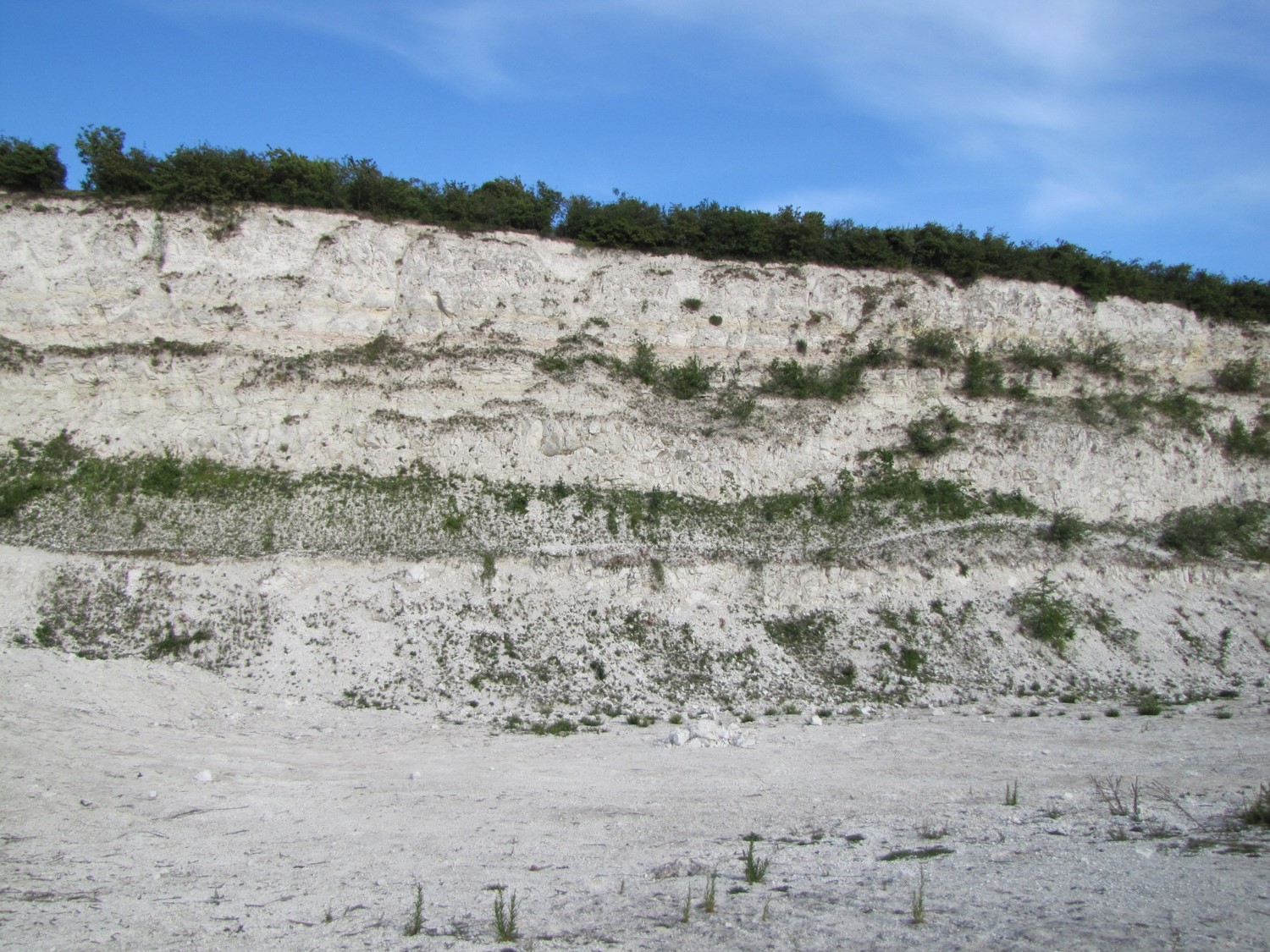
East Pit retains significant exposures of Late Cretaceous chalk representing the upper (younger) part of the Grey Chalk Sub-Group (previously referred to as the Lower Chalk) and the lower (older) part of the White Chalk Sub-Group (previously the Middle Chalk). The comprehensive deposits are now exposed in cliffs, about 20+ metres in height, and range in age from the late Cenomanian to early Turonian stages (about 95 to 93 million years old). The site is probably the best in the county where this age range of deposits can be viewed and, certainly, the most easily accessible.
Approximately 2-3 million years of chalk sediments are represented by the cliff faces. During this time there was a range of depositional environments affected by sea level and distance from land and, therefore, water depth and related ecology, which consequently produces differences in the components of the chalk itself (clay content, calcium carbonate content, fossil assemblage etc). This resulted in variation in the material of which the deposits comprise and, therefore, in the character of the strata. There is at least one band (the creamy-white limestone known as the Melbourn Rock) of relatively hard chalk (‘clunch’ used as building material) and several bands of clay-rich deposits (marls). Some strata are distinctly coloured such as the pink band above the Melbourn Rock and the yellow marl further above.
The deposits include identifiable bands such as the Plenus Marls and the Melbourn Rock that allow correlation with other local chalk deposits such as those at Steeple Morden Station Quarry, which are mostly younger (higher up in the White Chalk sequence), and those at Barrington Chalk Pit, which are older (the lower part of the Grey Chalk, including another hard band used for building, the Totternhoe Stone). Further correlation is possible across wider areas of the Chalk Group in Eastern and Southern England and also across the London-Paris Basin (and further afield).
Worldwide context – links with an extinction event
Isotopic evidence (Carbon 12 and Carbon 13) from the English Chalk, as well as from limestone deposits elsewhere in the world (e.g. United States, Tunisia and Italy), suggests there was a period of extensive deposition of organic carbon in many parts of the ocean at the boundary between the Cenomanian and Turonian Stages (around 93.5 million years ago). One of the possible causes was widespread depletion of oxygen (known as an Oceanic Anoxic Event). This boundary coincides with deposition of the Plenus Marls layer, identifiable at this site, and potentially links the deposits here to a regional, if not worldwide, event (OAE2) connected (in some way) with rising sea-levels and a significant extinction event.
Some of the deposits here (such as the marl bands in the Grey Chalk) may also be useful for correlation in cyclostratigraphy i.e. periodic decompositional cycles, such as those caused by changes in the geometry of the Earth’s rotation and of its orbit around the sun (Milankovich cycles). These cycles result in a repeating pattern of climatic fluctuation with frequencies of tens to hundreds of thousands of years and can relate to major planetary changes (including, significantly, those related to Ice Ages). Chalk deposition seems to have been particularly sensitive to these climatic cycles and can provide correlation for hundreds of kilometres, for example, across the Anglo-Paris Basin, and at a relatively high resolution (for deposits of this age).

One of the cliffs showing the levels of the various deposits and the position of the Cenomanian/Turonian boundary (c.93.5 mya) at which there was a significant anoxic event
(based on information from the Wildlife Trust BCN and Dr Peter Friend)
An engraving from 1822 showing fossil collectors at Cherry Hinton can be found here.
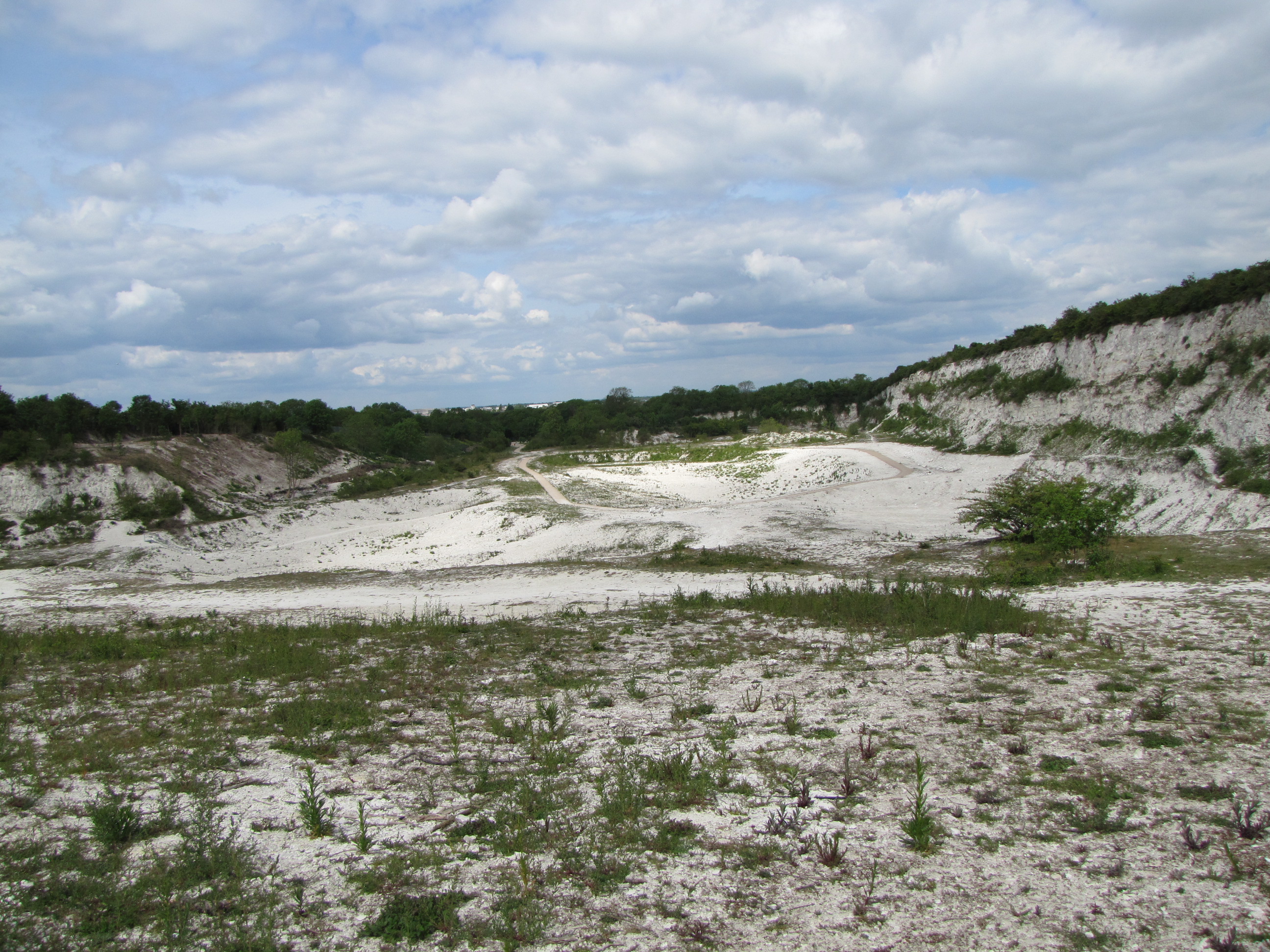
East Pit is also a Local Nature Reserve (LNR) and an SSSI (Site of Special Scientific Interest) for its biological value. The site is important for its chalk grassland flora including the moon carrot, a rare member of the family (the umbelifers) that includes carrot. It is also a good site for glow worms! Reprofiling of the base of the pit was carried out in 2009 to break up much of the solid chalk surface, which enabled wild flowers and grasses to spread and colonise the exposed chalk. Standing within the pit, you are surrounded by steep cliffs of chalk that glow in the late afternoon sun.
Download our East Pit leaflet


The site is owned and managed by the Wildlife Trust for Bedfordshire, Cambridgeshire and Northamptonshire. It is open to the public during daylight hours and has a network of paths where it is safe to walk and from which there are good views of the chalk cliffs (which must not be approached). There is wheelchair access to the site and several viewing areas are also accessible. Only access to the far end of the site is restricted to those who can use steps.Buses from the city centre run along Cherry Hinton Road, with stops near to the reserve. To visit, check the Wildlife Trust website. Note access and safety information on site.
Giant’s Grave LGS
The Chalk still provides a major water resource for the region. There are major springs along the outcrop of the Burwell Rock (Totternhoe Stone), a band of relatively hard rock within the Grey Chalk that lies just under the base of the exposed deposits at East Pit. Water from this band surfaces a short distance to the north, at a spring near to the site at Giant’s Grave, another Local Geological Site. Owned and managed by Cambridge City Council, it is also a City Wildlife Site,
Giant’s Grave is a much-modified spring-sapped hollow containing a shallow pond, fed by a chalk spring issuing from the Totternhoe Stone, a hard, band of Chalk that forms the lowest stratum of the Zig Zag Chalk. Its highly-fissured (water transporting) nature produces a spring line above the relatively impermeable West Melbury Marly Chalk that lies at the base of the Chalk slope. The site is geologically connected to East Pit Local Geological Site only 0.5km to the south where the Totternhoe Stone underlies the exposed Zig Zag Chalk. This spring is analogous to those at Nine Wells LGS and Burwell Spring LGS where the water also emanates from the Totternhoe Stone.
The spring’s name may have originated from the Iron Age burials of relatively tall people discovered on nearby Lime Kiln Hill or from the association with one of the legendary giants, Gog and Magog (or one giant Gogmagog). The site is a public open space and a City Wildlife Site, well-known locally as an aesthetically attractive, pond-filled hollow, and an unexpected ‘green oasis’ immediately adjacent to a busy High Street and cross-roads. It is also part of a green corridor into the city. The spring is the source of the Cherry Hinton Brook, a chalk stream which flows north to the Cam and once supported watermills and a paper mill. From 1853 until 1907 the spring was the City’s main source of water. It contributed to the growth of the village of Cherry Hinton, particularly its growth in the 19th century, and was also important to the Cambridge University and Town Waterworks Company in the late 19th century. There is an information board on site giving details of local archaeology.
The pond and immediate surrounding area is a public open space, freely and easily accessible and the pond can be viewed from the pavement alongside the street.


